File:Paladin kings row map.png
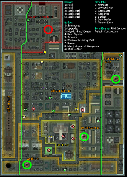
Revision as of 17:49, 5 June 2021 by AboveTheChemist (talk | contribs) (Map showing Paladin constructions sites (green circles) and Paladin destination location (red circle) Category:VidiotMaps)

Size of this preview: 430 × 600 pixels. Other resolution: 466 × 650 pixels.
Original file (466 × 650 pixels, file size: 473 KB, MIME type: image/png)
Summary
Map showing Paladin constructions sites (green circles) and Paladin destination location (red circle)
File history
Click on a date/time to view the file as it appeared at that time.
| Date/Time | Thumbnail | Dimensions | User | Comment | |
|---|---|---|---|---|---|
| current | 20:26, 5 June 2021 |  | 466 × 650 (473 KB) | AboveTheChemist (talk | contribs) | Added marker for AE location (the nearest police drones) |
| 17:49, 5 June 2021 |  | 466 × 650 (472 KB) | AboveTheChemist (talk | contribs) | Map showing Paladin constructions sites (green circles) and Paladin destination location (red circle) Category:VidiotMaps |
You cannot overwrite this file.
File usage
The following page uses this file: